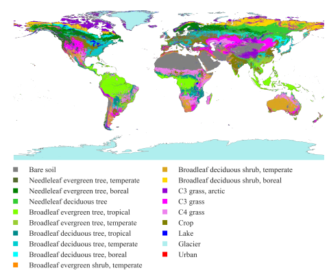
This dataset presents land surface parameters designed explicitly for global kilometer-scale Earth system modeling and has significant implications for enhancing our understanding of water, carbon, and energy cycles in the context of global change. Specifically, it includes four categories of...
Filter results
Category
- (-) Coastal Science (4)
- (-) Wind Energy (1)
- Scientific Discovery (307)
- Biology (198)
- Earth System Science (136)
- Human Health (102)
- Integrative Omics (73)
- Microbiome Science (42)
- Computational Research (23)
- National Security (21)
- Computing & Analytics (14)
- Chemistry (10)
- Energy Resiliency (9)
- Data Analytics & Machine Learning (8)
- Materials Science (7)
- Visual Analytics (6)
- Chemical & Biological Signatures Science (5)
- Computational Mathematics & Statistics (5)
- Weapons of Mass Effect (5)
- Atmospheric Science (4)
- Ecosystem Science (4)
- Renewable Energy (4)
- Data Analytics & Machine Learning (3)
- Plant Science (3)
- Cybersecurity (2)
- Distribution (2)
- Electric Grid Modernization (2)
- Energy Efficiency (2)
- Energy Storage (2)
- Grid Cybersecurity (2)
- Solar Energy (2)
- Bioenergy Technologies (1)
- Computational Mathematics & Statistics (1)
- Grid Analytics (1)
- High-Performance Computing (1)
- Subsurface Science (1)
- Terrestrial Aquatics (1)
- Transportation (1)
Content type
Supporting data and code uploaded to DataHub for "How do the weather regimes drive wind speed and power production at the sub-seasonal to seasonal timescales over the CONUS?" Created by Ye Liu*, Sha Feng*, Yun Qian, Berg K Larry, Huilin Huang *POC: Ye Liu, Ye.Liu@pnnl.gov Sha Feng, sfeng@pnnl.gov --...
Category
Category
Datasets
1
The year 2014 solution files are based on model calibration effort based on inputs and data from Year 2014 as described in Khangaonkar et al. 2018). It includes water surface elevation, currents, temperature and salinity at an hourly interval. These netcdf files with 24 hourly records include...
Category
The year 2014 solution files are based on model calibration effort based on inputs and data from Year 2014 as described in Khangaonkar et al. 2018). It includes water surface elevation, currents, temperature and salinity at an hourly interval. These netcdf files with 24 hourly records include...