Description
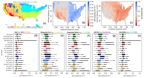
We have aggregated the most recent soil moisture datasets from a diverse range of sources, encompassing the Continental United States (CONUS). These sources encompass gridded data from remote sensing products, reanalysis products, machine learning-based projects, and land surface modeling products. Additionally, we have obtained and processed in-situ soil moisture observations from the International Soil Moisture Network.
The collected datasets exhibit variations in both temporal and spatial resolutions. Among the 20 datasets, six are available at a spatial resolution of 0.25 degrees, while three are at a coarser spatial resolution of 25 km. To minimize spatial interpolation, we conducted data uncertainty evaluations at the 0.25-degree spatial resolution. For our data evaluations, we maintained a monthly temporal resolution, which effectively captures soil moisture seasonality and interannual variability. Our data processing strategy preserves the raw data and interpolated data at their original temporal resolutions. Datasets with higher temporal resolutions, including daily, three-hourly, and hourly datasets, are set aside for subsequent analyses. These analyses will delve into topics such as soil moisture changes and recovery during extreme weather events.
Furthermore, we have processed auxiliary data to enhance our evaluation, leveraging tools such as Google Earth Engine. This includes incorporating topography data, land use land cover data, Köppen-Geiger climate classification, and more to provide a comprehensive assessment from multiple sources.

