Description
Extreme weather events, including fires, heatwaves(HWs), and droughts, have significant impacts on earth, environmental, and power energy systems. Mechanistic and predictive understanding, as well as probabilistic risk assessment of these extreme weather events, are crucial for detecting, planning for, and responding to these extremes. Records of extreme weather events provide an important data source for understanding present and future extremes, but the existing data needs preprocessing before it can be used for analysis. Moreover, there are many nonstandard metrics defining the levels of severity or impacts of extremes.
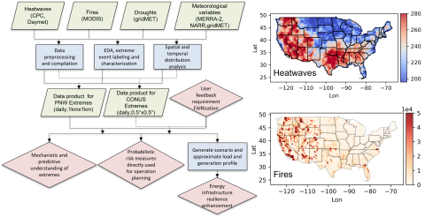
In this study, we compiled a comprehensive benchmark data inventory of extreme weather events, including fires, HWs, and droughts. The dataset covers the period from 2001 to 2020 with a daily temporal resolution and a spatial resolution of 0.5°×0.5° (~55km×55km) over the continental United States (CONUS), and a spatial resolution of 1km × 1km over the western US (WUS) region, together with the co-located and relevant meteorological variables. By exploring and summarizing the spatial and temporal patterns of these extremes in various forms of marginal, conditional, and joint probability distributions, we gain a better understanding of the characteristics of climate extremes. The resulting AI-ready data inventory can serve the following purposes: (1) support the mechanistic and predictive understanding of extreme events and their impact on the earth's biological and environmental systems; (2) provide probabilistic maps for both individual and compound extreme events, enhancing the direct risk assessment of these extreme weather events for future detection, planning, and decision making; (3) generate various extreme event scenarios and approximate electricity load and generation profiles in energy systems to enhance infrastructure resilience in the face of extreme events.

