Description
The SATELLITE_EAGLES_PNNL NetCDF dataset contains a suite of satellite- and reanalysis-derived atmospheric and surface parameters on a regular latitude–longitude grid. The dataset includes core geophysical fields such as land fraction, aerosol optical depth at multiple wavelengths (465, 550, 667, and 865 nm), sea surface temperature, estimated inversion strength, and various thermodynamic and dynamic quantities (e.g., relative humidity, vertical velocity, boundary-layer height, and surface fluxes) from both MERRA and ERA reanalysis products, provided as daily-mean and instantaneous values.
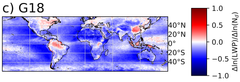
A major component of the dataset consists of MODIS-retrieved cloud microphysical properties, including cloud droplet number concentration, cloud effective radius, optical thickness, and liquid water path, provided for three compositing regimes (“All,” “Q06,” and “G18”). Corresponding cloud-top parameters—temperature, height, and pressure—along with total and domain-mean cloud fraction fields are also included. The file further integrates additional satellite data from AMSR-E (for cloud water, rain water, and surface precipitation retrievals) and CERES (for top-of-atmosphere radiative fluxes, cloud fractions, and albedo).
This dataset is designed to evaluate aerosol–cloud interactions in warm clouds, emphasizing the use of MODIS for deriving cloud droplet number concentration and liquid water path statistics. The complementary satellite and reanalysis fields are co-located and time-matched to the same instantaneous MODIS observations, enabling consistent comparisons between cloud properties, aerosol loading, and large-scale meteorological conditions.

