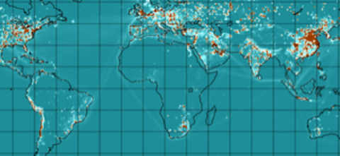
CMIP6 historical anthropogenic emissions data from 1980 - 2019 mapped to a 0.1° global grid. The underlying data is identical to that from the 0.5° v2021_04_21 version of this also available at this archive. The 0.5° data was downscaled to 0.1° using 0.1° proxy data from EDGAR. See: https://github...
Filter results
Content type
Dataset Type
Tags
- (-) Emissions (1)
- Air Pollution (1)
- Data inventory (1)
- Droughts (1)
- Extreme weather (1)
- Fires (1)
- Greenhouse Gases (1)
- Heatwaves (1)
- High-Performance Computing (1)
- ML/AI (1)
- MultiSector Dynamics (1)
- Output Databases (1)
- Polycyclic Aromatic Hydrocarbons (1)
- Processed Data (1)
- Superfund Hazardous Substances (1)
- Toxicology (1)
Showing 1 - 1 of 1