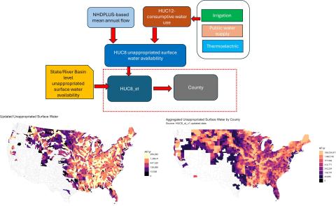
Description
The quantity of fresh surface water that is available for development according to the managing state or river basin authority. See Tidwell et al. 2014 for details concerning how the metric was quantified. This update includes the following changes:
- Updated USGS streamflow data now available at a HUC12 level (see https://water.usgs.gov/catalog/datasets/8a60b6b4-d785-4265-af99-cd1870e…).
- Updated USGS water consumption data including agricultural, thermoelectric and municipal uses (see https://water.usgs.gov/nwaa-data/data-catalog/sector/water-use).
- Adjusted water access costs for inflation.
- Also updated HUC12 numbering to be consistent with Version 2 of the National Hydrography Dataset.
Date: 2020 data and dollars
Output Format: Excel
Spatial Resolution: HUC8 and County
[1] Tidwell, V.C, Moreland, B.D., Zemlick, K.M., Roberts, B.L., Passell, H.D., Jensen, D., Forsgren, C., Sehlke, G., Cook, M.A., King, C.W. & Larsen, S. (2014). Mapping water availability, projected use and cost in the Western United States, Environmental Research Letters, 9(6), doi:10.1088/1748-9326/9/6/064009.
English