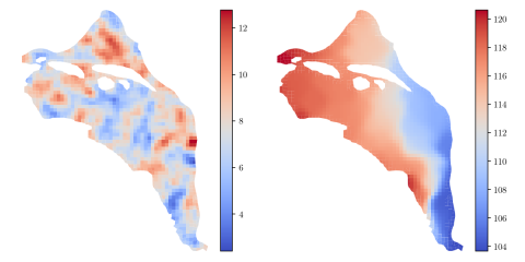
HDF5 file containing 10,000 hydraulic transmissivity inputs and the corresponding hydraulic pressure field outputs for a two-dimensional saturated flow model of the Hanford Site. The inputs are generated by sampling a 1,000-dimensional Kosambi-Karhunen-Loève (KKL) model of the transmissivity field...
Filter results
Category
- (-) Atmospheric Science (3)
- (-) Coastal Science (3)
- (-) Data Analytics & Machine Learning (3)
- (-) Wind Energy (1)
- Scientific Discovery (182)
- Biology (109)
- Earth System Science (89)
- Human Health (70)
- Integrative Omics (53)
- Microbiome Science (16)
- National Security (14)
- Computing & Analytics (10)
- Computational Research (9)
- Energy Resiliency (7)
- Visual Analytics (6)
- Computational Mathematics & Statistics (3)
- Data Analytics & Machine Learning (3)
- Renewable Energy (3)
- Chemical & Biological Signatures Science (2)
- Cybersecurity (2)
- Distribution (2)
- Ecosystem Science (2)
- Electric Grid Modernization (2)
- Grid Cybersecurity (2)
- Weapons of Mass Effect (2)
- Bioenergy Technologies (1)
- Chemistry (1)
- Computational Mathematics & Statistics (1)
- Energy Efficiency (1)
- Energy Storage (1)
- Grid Analytics (1)
- High-Performance Computing (1)
- Plant Science (1)
- Solar Energy (1)
- Subsurface Science (1)
- Terrestrial Aquatics (1)
- Transportation (1)
Content type
Comprehensive assessment of climate datasets created by statistical or dynamical models is important for effectively communicating model projection and associated uncertainty to stakeholders and decision-makers. The Department of Energy FACETS project aims to foster such communication through...
Category
Category
The year 2014 solution files are based on model calibration effort based on inputs and data from Year 2014 as described in Khangaonkar et al. 2018). It includes water surface elevation, currents, temperature and salinity at an hourly interval. These netcdf files with 24 hourly records include...
Category
ProxyTSPRD profiles are collected using NVIDIA Nsight Systems version 2020.3.2.6-87e152c and capture computational patterns from training deep learning-based time-series proxy-applications on four different levels: models (Long short-term Memory and Convolutional Neural Network), DL frameworks...
Supporting data and code uploaded to DataHub for "How do the weather regimes drive wind speed and power production at the sub-seasonal to seasonal timescales over the CONUS?" Created by Ye Liu*, Sha Feng*, Yun Qian, Berg K Larry, Huilin Huang *POC: Ye Liu, Ye.Liu@pnnl.gov Sha Feng, sfeng@pnnl.gov --...
Category
This dataset presents land surface parameters designed explicitly for global kilometer-scale Earth system modeling and has significant implications for enhancing our understanding of water, carbon, and energy cycles in the context of global change. Specifically, it includes four categories of...
Extreme weather events, including fires, heatwaves(HWs), and droughts, have significant impacts on earth, environmental, and power energy systems. Mechanistic and predictive understanding, as well as probabilistic risk assessment of these extreme weather events, are crucial for detecting, planning...